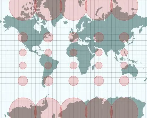
Correcting the Colonial Cartographic Bias
The United Nations recently adopted the Equal Earth projection, a new map design that corrects long-standing size inaccuracies. Developed by three cartographers, this project aims to replace the outdated Mercator projection. By providing a more realistic representation of landmasses, the map shifts how the world visualizes the true scale of continents.
Latest news
 UN Report Accuses US and Iran of Serious Human Rights Violations
 Canada Eyes EU Associate Membership Under Prime Minister Mark Carney
 Fiji Declares National Emergency Over Rapid HIV Surge
 Israeli Forces Detain Palestinian Journalist in Ramallah Raid
The Mercator projection, dating back to the 16th century, has long dominated global geography. It notoriously inflates the size of Europe and North America while shrinking Africa and South America. This distortion has influenced global perceptions for centuries. The creators of the Equal Earth map sought to rectify these biases through precise mathematical modeling.
The cartographers designed their projection to prioritize geographic integrity over navigation convenience. While the Mercator map was originally intended for sea travel, it became the standard for classrooms and political offices. The new alternative restores visual balance, allowing viewers to compare the vast scale of Africa against other regions accurately.
Can Maps Ever Be Truly Objective?
Despite the widespread adoption by the UN, the transition has not been entirely smooth. Some diplomats expressed frustration with the change, likely due to deep-seated familiarity with the traditional, albeit inaccurate, world view. The creators remain surprised by the speed at which their work gained international recognition and official status.
Cartography has never been a neutral science. Every map projection involves trade-offs, as flattening a sphere onto a two-dimensional surface inevitably causes distortion. By choosing which elements to preserve, mapmakers inherently make political and social decisions. The Equal Earth projection serves as a reminder that our view of the world is a human construct.
Frequently Asked Questions
Moving forward, this adoption signals a shift toward more equitable global representation. As international institutions move away from colonial-era standards, the way we teach geography will likely evolve. This change encourages a more nuanced understanding of global proportions and challenges the dominance of Western-centric mapping traditions.
Why is the Mercator projection considered inaccurate? It prioritizes straight lines for navigation but severely distorts the size of landmasses near the poles. This makes regions like Greenland appear larger than the entire African continent.
How does the Equal Earth map differ from older designs? It maintains the relative size of continents more accurately than traditional models. This allows for a better visual comparison of land areas across the globe.